Tracking Toxins
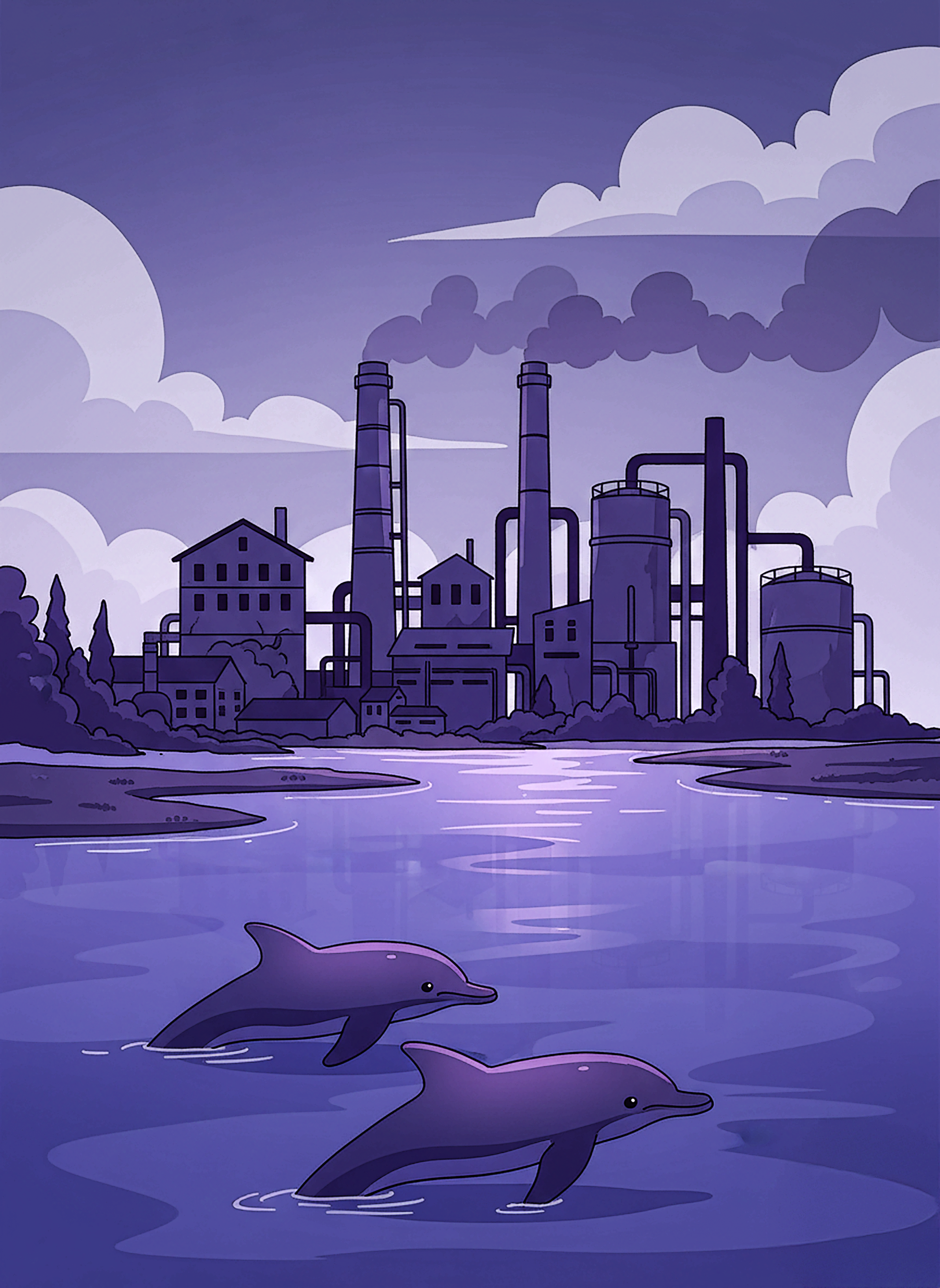
Years after the cleanup efforts began, can a legacy of industrial pollution still be detected in local dolphins near Brunswick, Georgia?
Background:
For 75 years, a large industrial site on the waterfront in Brunswick, Georgia helped support the local economy by providing jobs and making products. Over that time period, the site was used by a series of five different companies. Altogether it was home to a power plant, an oil refinery, a facility for making paint and varnish, and a factory that produced chlorine and other strong chemicals.
By 1994 the long history of industrial use at the waterfront site had led to contamination of the soil, groundwater, and sediment along the coast from mercury, PCBs, lead and other hazardous substances. The Environmental Protection Agency (EPA) then made the decision to shut down the plant. LCP chemicals, the owner of the site at that time, declared bankruptcy and the EPA ordered a cleanup of the 681 acres of marsh and 88 acres of dryland through the Comprehensive Environmental Response, Compensation, and Liability Act (CERCLA).
CERCLA is the law that allows the EPA to both hold industries responsible and fund cleanup of sites so polluted that they are a danger to humans and the surrounding ecosystem. When this law is used, the site of the cleanup becomes known as a Superfund site.
Once CERCLA was applied in Brunswick at the LCP Chemicals location, it became a Superfund site and the cleanup effort has been ongoing since then. (Unfortunately, there are also 3 other Superfund sites nearby within the same county!)
As part of the ongoing effort to bring the Brunswick ecosystem back to health, scientists have been studying dolphins that live in the Brunswick area. Scientists are working to find out how pollution may be affecting the dolphins overall health, as well as their ability to reproduce. They are also looking at things that affect how the dolphin population changes over time, like how many dolphins survive each year and whether dolphins are moving in or out of the area.
A main pollutant of concern is PCB - a chemical which was used from 1920 - 1979 before it was banned in the United States. The PCB ban came from the realization that the chemical was both harmful and building up in sediments and being found in the bodies of animals and humans alike. Glynn County (where Brunswick is located) has been shown to have high levels of PCB in the sediments surrounding the Superfund sites. PCBs are known to accumulate in the fatty tissues of animals at the top of the food chain through a process known as biomagnification.
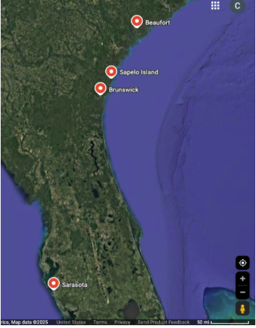
In one study that you will explore data from, researchers took blood and small tissue samples from bottlenose dolphins (Tursiops truncatus) at four different locations. The locations included two locations far from Brunswick:
Beaufort, NC
Sarasota, FL
…as well as two locations known to be directly contaminated by the Brunswick Superfund site:
Brunswick, GA
Sapelo, GA - 40 miles north of Brunswick
Using a catch-and-release method, scientists compared dolphin contamination in these four locations in hopes of getting a bigger picture of the extent of marine pollution. Understanding how the superfund site pollution (especially PCB levels) in the area is affecting wildlife along the coast of Georgia could lead to next steps in clean up, and also immediate recommendations for seafood consumers.
Explore the dataset to compare the levels of PCBs and other pollutants in dolphins close to the Brunswick Superfund sites to those of dolphins far from the site.
Dataset
These data for Sapelo and Brunswick were collected in August 2009 during a 2 week period along the coast of Georgia. These data were originally published in the journal Proceedings of the Royal Society B: Biological Science. The author also provided us with additional raw data for use in this exercise. You can see the original scientific paper here.
The data for Beaufort and Sarasota were gathered during a different field study but used as a baseline here so that you can compare samples from dolphins near the Brunswick Superfund sites to samples from dolphins that live far from those sites . The original study for these data can be found in this paper.
Researchers captured dolphins using a net that was over 1000 feet long. They then worked quickly to take blood as well as small skin and blubber samples from the dolphins to measure pollutant levels that had accumulated. The dolphins were immediately released back to the wild after the samples were taken. The researchers then brought the tissue samples back to the lab where they measured levels of several pollutants in the tissue samples including PCB, BDE, Chlorodane, and DDT.
Samples were taken from two locations close to the Brunswick Superfund site. Those locations were Brunswick and Sapelo. Samples were also taken from two locations far from the Brunswick Superfund site. Those were Sarasota and Beaufort.
Each row (observation) in this dataset represents an individual dolphin.
Variables
Dolphin sample # - This info variable lists the ID number given to a specific dolphin sample. Each sample comes from a different individual dolphin.
Site - This categorical variable indicates the location where the dolphin was found,sampled and released. Values include Brunswick, Sapelo, Sarasota, and Beaufort.
PCB (ppm) - This numeric variable measures the amount of PCB as measured in the tissue sample from the dolphin. Measured in parts per million (ppm). PCBs were known to be used at the LCP Chemicals site.
BDE (ppm) - This numeric variable measures the amount of BDE as measured in the tissue sample from the dolphin. Measured in parts per million (ppm). BDE was known to be used at the LCP chemicals site.
Chlordane (ppm) - This numeric variable measures the amount of Chlordane as measured in the tissue sample from the dolphin. Measured in parts per million (ppm). Chlordane is a now banned pesticide and is not known to have been manufactured at the LCP Chemicals site.
DDT (ppm) - This numeric variable measures the amount of DDT as measured in the tissue sample from the dolphin. Measured in parts per million (ppm). DDT is a now banned pesticide and is not known to have been manufactured at the LCP Chemicals site.
Activity
Part 1: Explore the dataset
1. Make a graph to compare the number of dolphins sampled close to the Superfund sites in Brunswick, GA to those sampled far from the superfund site.
Make a graph showing just the variable called Site. You can select any of the three basic graph types to do this using the icons that look like this:

Screenshot and paste your graph below:


2. Looking at the above graph that you made, how many dolphins were sampled at each of the four locations?
3. How many total dolphins were sampled from locations close to the Brunswick Superfund sites and how many were sampled from locations far from those sites? Look at the dataset description or the map above if you need to.
4. Were the total number of dolphins included in this dataset more or less than you expected? Explain your thinking.
Part 2: Make Predictions
5. For each of the 4 pollutants measured in the study, make predictions based on the location where the sample was collected. Refer to the descriptions of the variables in the Dataset section above to help inform your predictions.
You can structure your predictions like this:
In the locations close to the Brunswick Superfund sites the levels of (pollutant) in the dolphins will be (higher than/lower than/the same as) the levels found in dolphins collected at locations far from the Brunswick Superfund sites.
a) PCB: In the locations close to the Brunswick Superfund sites the levels of PCB in the dolphins will be _________________ the levels found in dolphins collected at locations far from the Brunswick Superfund sites.
b) BDE: In the locations close to the Brunswick Superfund sites the levels of BDE in the dolphins will be _________________ the levels found in dolphins collected at locations far from the Brunswick Superfund sites.
c) Chlordane: In the locations close to the Brunswick Superfund sites the levels of Chlordane in the dolphins will be _________________ the levels found in dolphins collected at locations far from the Brunswick Superfund sites.
d) DDT: In the locations close to the Brunswick Superfund sites the levels of DDT in the dolphins will be _________________ the levels found in dolphins collected at locations far from the Brunswick Superfund sites.
Part 3: Test your predictions with the data
Use the graphs made with dots and lines for all the graphs in this section.

6a. Make a graph of Site on the x-axis and PCB (ppm) on the y-axis. Select the check box to add descriptive stats. This will add bars to your graph. The height of the bars will show the average for each site. Screenshot your graph below:

Do the data in your graph support or not support your prediction from 5a? Explain your answer.
6b. Make a graph of Site on the x-axis and BDE (ppm) on the y-axis. Select the check box to add descriptive stats. This will add bars to your graph. The height of the bars will show the average for each site. Screenshot your graph below:

Do the data in your graph support or not support your prediction from 5b? Explain your answer.
6c. Make a graph of Site on the x-axis and Chlordane (ppm) on the y-axis. Select the check box to add descriptive stats. This will add bars to your graph. The height of the bars will show the average for each site. Screenshot your graph below:

Do the data in your graph support or not support your prediction from 5c? Explain your answer.
6d. Make a graph of Site on the x-axis and DDT (ppm) on the y-axis. Select the check box to add descriptive stats. This will add bars to your graph. The height of the bars will show the average for each site. Screenshot your graph below:
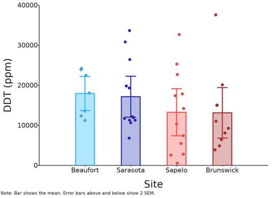
Do the data in your graph support or not support your prediction from 5d? Explain your answer.
Part 4: Consider the big picture
7.How many years passed between the United States banning the use of PCB (in 1979) and the sampling of the dolphins in this study?
8. Both PCB and BDE are known to be harmful to humans and other animals. Both chemicals are known to accumulate in the tissue of animals higher in the food chain due to biomagnification.
What might this dataset mean to people near the Brunswick Superfund sites who would like to consume fish caught in the waters near Brunswick?