Anticipating Earthquakes
Is there a most dangerous place on earth for Earthquakes?

Background
Earthquakes are happening all the time, but their effects on human lives can vary wildly. Sometimes they occur and are imperceptible and other times they create massive damage and disasters. Every decade or so, we hear about cities being leveled in minutes by an earthquake. And yet, there are many days when seismographs pick up earthquakes occurring that aren’t even felt by humans.
As the earth’s tectonic plates continue to move, we can ask: are earthquakes becoming more intense? Where do the most intense earthquakes tend to occur?
Because earthquakes are so frequent (Alaska reports an earthquake almost every day!) and can be easily tracked anywhere in the world, we have a vast amount of data on these plate slips. With these data, we can determine the safest locations in the world to live and the places most at risk from intense earthquakes.
Examine the data to learn where earthquakes are most often occurring and to see if they are happening more often!!

Image accessed from WorldAtlas.com on Feb 2024

Dataset
This data set was sourced from kaggle.com. While the original dataset covers 1965 - 2016, we reduced the size of the dataset by taking a subset of the data that includes only earthquakes occurring from Jan 2010 - Dec 2016. The original dataset was collected by The National Earthquake Information Center (NEIC) and lists earthquakes recorded worldwide with a magnitude of 5.5 or greater.
Variables
Date - This info variable lists the date of the recorded earthquake. It cannot be used in your analysis
Days since Jan 1, 2010 - This numeric variable measures how many days it has been since the start of the dataset, January 2, 2010. It is a measure of date that can be used in your analysis.
Latitude - This numeric variable indicates the latitude measurement for that earthquake’s location. Measured in degrees.
Longitude - This numeric variable indicates the longitude measurement for that earthquake’s location. Measured in degrees.
Depth (m) - This numeric variable measures the depth of the earthquake's epicenter. Measured in meters.
Magnitude - This numeric variable is a logarithmic measurement of the intensity (or amplitude) of the seismic wave produced by the earthquake. Values are measurements aligned to the Richter scale. Because the scale is logarithmic, an earthquake of 6.0 on the Richter scale is 10 times more intense than a 5.0 and a 7.0 is 100 times greater.
Activity
We will be trying to answer the following questions using data:
Question 1: Have earthquakes increased (in number, or intensity) over time?
Question 2: Is there a most dangerous place on earth for earthquakes?
Investigating Question 1: Have earthquakes increased in intensity over time?
How has the intensity of earthquakes changed over time? Use the Make a Graph tool to create a dot graph for Days since Jan 1, 2010 vs. Magnitude graph by showing Days since Jan 1, 2010 as X variable, and Magnitude as Y variable. Add a Regression line to help visualize any trend over time.
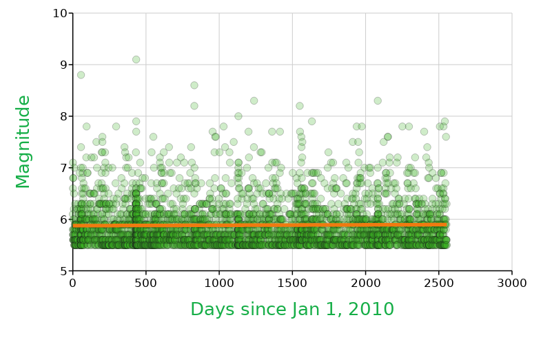
2) What kind of pattern do you see emerging from the intensity of earthquakes over time (if there is one…if not, describe what you see as evidence).
3) Have the amount of earthquakes increased over time? Change your graph type to one made with rectangles (commonly called bar graphs) and putDays since Jan 1, 2010 as the x variable. Screenshot your new graph below:
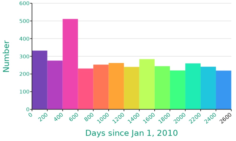
4) What kind of pattern do you see emerging from the amount of earthquakes over time (if there is one…if not, describe what you see as evidence).
Investigating Question 2: Is there a most dangerous place on earth for earthquakes?
5) Where are earthquakes showing up in the world? Make two bar graphs, one with Longitude as the X variable and one with Latitude as the X variable. Number should be your y-axis label. Include screenshots of both graphs below:

6) Do you see evidence for earthquakes occurring more in specific parts of the world? Which locations seem to have the most, if any?
7) What kind of pattern do you see for intensity of earthquakes vs. where they are located in the world? Use the Make a Graph tool to create a scatter plot with Longitude as your X variable, Latitude as the Y variable, and Magnitude as the Z variable. Screenshot your graph and include it below:

8) Take another look at the image of tectonic plates on the Earth - what do you notice about the graph you created in #7 and this image?
9) We know that magnitude of earthquakes matters to describe the level of danger to our infrastructure, but one additional variable to evaluate is the depth of the earthquake. The deeper the earthquake, the less it impacts us at the surface if all else is equal.
Make another graph to investigate how depth relates to location. Keep Longitude as your X variable and Latitude as the Y variable, but now select Depth as the Z variable. Screenshot your graph and include it below:

10) Describe any patterns that you see when comparing the two scatterplots that you made in #7 and #9.
11) Looking at the data from #5-10 , how would you answer Question 2: Is there a most dangerous place on earth for earthquakes?
*Teachers can request an answer key through the form below.